
World Rivers Day – The Sands, Gympie
GYMPIE URBAN RIVERS COMMUNITY AWARENESS DAY
Sunday 27 September 2026 – World Rivers Day
The Mary River at the Sands in Gympie will be on show on World Rivers Day – Sunday 27th September 2026 for an interactive and educational family friendly day aimed at helping locals learn more about our river.
The Mary River Catchment Coordinating Committee (MRCCC) is hosting a Community Awareness Day to herald a new chapter for the river —one defined not by gold mining and extraction, but by restoration. The Community Awareness Day offers a range of options for people to learn more about the river and the restoration work being undertaken to improve river health. Activities will run from 7am to early afternoon and include:
- Early morning bird walk along the river with the Gympie Field Naturalists;
- Kabi Kabi (Gubbi Gubbi) Traditional owner Welcome to Country;
- River trail exploration walk and talk with MRCCC, Kabi Kabi and Gympie Landcare;
- Tree planting by Gympie Landcare;
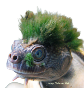
- Best punk hairstyle competition with prizes for the winners! (in honour of Chris van Wyk’s world famous photo of the Mary River turtle with algae on its head);
- Displays and information about the Mary River, its unique aquatic threatened species and rehabilitation activities;
- Information stalls – Gympie Regional Council, Gympie Landcare, MRCCC, Kabi Kabi (KKPAC)
- Sausage Sizzle with Gympie South Lions
Together with Gympie Council, Gympie Landcare and the Kabi Kabi People’s Aboriginal Corporation, the MRCCC is working to restore the Gympie urban reach of the Mary River. This project is funded through the Australian Government’s Natural Heritage Trust under the Urban Rivers and Catchments Program, with the support of Mary River Catchment Coordinating Committee
Building on years of local knowledge and previous rehabilitation work, strategic weed removal of vine weeds such as Cat’s claw vine and riparian revegetation are helping to stabilise vulnerable riverbanks, protect habitat for the critically endangered Mary River turtle and White-throated snapping turtle, the endangered Mary River cod and Grey headed flying fox and the vulnerable lungfish, and decrease the amount of sediment washing down the river and entering the Great Barrier Reef.
Federal Minister for the Environment and Water Murray Watt said the project is significant for the Mary River.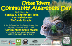
“Removing weeds and sediment will improve the water quality of the river which is habitat to unique species including the critically endangered Mary River turtle”, he said.
“The Albanese Government is proud to support initiatives like this that restore habitat and provide improved access to nature for local communities.”
“Recovery of the Mary River through Gympie is not an overnight transformation,” said MRCCC’s Urban Rivers Project Manager, Kath Bennett. “Since gold mining stopped in the river around 100 years ago, ongoing rehabilitation and stabilisation of the riverbanks has required a consistent approach that depends on sustained effort, community involvement and respect for the river’s natural rhythms.”
“We are inviting the community to come along on Sunday 27th September to find out what is happening through this project and get involved in helping to protect our beautiful Mary River and the natural environment,” Kath said.
The Gympie Urban Rivers Project will continue until early 2028, providing plenty of opportunities for the community to support the program and contribute to protection and rehabilitation of the Mary River and its riverine environment.
Community Awareness Day
Sunday 27 September 2026 – World Rivers Day
The Sands, Gympie
7am to early afternoon
The aim of World Rivers Day is to encourage active stewardship and protection of rivers everywhere and increase public awareness about the vital role of waterways #ShoutOutForRivers